Trekking - Annapurna - Annapurna Circuit Trek
Annapurna Circuit Trek (21 Days)
Trip Facts
 Trekking Type: Lodge/Camping Trek
Trekking Grade: ▲▲▲ (?)
Maximum Altitude: 5416 m.
Best Season: October - November, March - April
An extraordinary land! A trek takes you from 1,500 feet/400meters to 18,000 feet/5416meters and back. You will meet ten ethnic groups, pass through four climate zones. Vast contrast in landscape and vegetation exotic flora & fauna, mountain scenery from every angle. Little wonders why this continues to be the favored trekking region. Although this is the most popular trek in Nepal, be assured, as with all our trips, we always endeavor to choose secluded campsites away from the normal tourist areas. You will be rewarded with your efforts when completing this trek around the entire Annapurna massif. Walk through the quaint lowland villages, lush subtropical forest up to the remote Manang region resembling the medieval era. Make your way up to the Thorong La pass at 5,416m, and cross down into another valley. The colors, landscape and terrain are comparable to Tibet; you will be walking amongst the highest mountain masses in the world. Trek along the Kali Gandaki, the worlds deepest gorge, all the way down the other side of the valley back into scattered lowland settlements completing the circuit will leave you inspired, with a real sense of achievement. Spend a night and a day in lakeside Pokhara before returning to Kathmandu. This trek starts from the small hill town called Besishahar.
Then we will follow the entire gorge track up to the Dharapani. Nothing more we will be able to explore forest, villages and river views on this part of the trek. But from Dharapani we will allow to enter the Himalayan valley. This part of you trek is one of the most beautiful. Both side we will see Snow Mountains. The southern Part will be Annapurna range and the north Manaslu Range in-between the nice Manang valley. Manang is our rest day for trek and we will acclimatize here for one day. This area is covered with Gurung people, the small district of Nepal by population. Next two days of course the challenging days for us to cross the high pass. Thorong La (5416m). After two days hard snow walking we come to the dry and windy place Muktinath Temple (3843m). For couple of days we walk down wards through the Kaligandaki River up to the hot spring at Tatopani, day rest. Again from tomorrow for two days we need to walk up to reach Ghorepani (2834m). From this scenic place we will descend all the way down to Birethanti where our trek ends and continue to Pokhara.
Trekking Itinerary
Day 1: Arrival in Katmandu reception at airport meet and greet with flower garland and transport to Hotel Nirwana garden and evening Trek briefing with welcome dinner overnight in Hotel.1 triple in bb plan.
Day 2: kathmandu -to- Benshi shahar by private transportation 6/7 hours drive (820m.) from your hotel after your breakfast by private transportation drive to Benshi sahar with your guide and porters, for Lunch they will stop on the way and for you will be prepared pack lunch from kathmandu and evening in Bensi sahar staying in nice lodge.
Day 3: Trek to NGADI (930m.) 4/5 hours walk.
From Besi Sahar the trail descends sharply then climbs steeply through the deep gorge. It moves up and down through fields, tropical forest and small hamlets to khudi at 845m, the first Gurung village. Most people are Brahmin or Chetri with a few Gurung villages. Northwards up the Marsyangdi valley cross over a suspension bridge in Bulbule Good views of Manaslu and Ngadi Chuli. Ngadi is a small settlement. overnight nice lodge.
Day 4: Trek to SYANGE (1100m.) 6 hours walk.
cross the long suspension bridge over the Ngadi Khola. Follow the trail marked signs saying "manang"and climb gradually at first and steeply the last bit as it moves through scrub forest into Bahundanda.Descent to a stream is along a steep, slippery trail then pass a huge slide area to khane at 1180m.overnight nice lodge with waterfall view.
Day 5: Trek to Dharapani (1890m.) 7 hours walk.
The trail continues across the plateau beyond taal over a forested ridge, Taal lies at the foot of a picturesque waterfall at 1675m.and across a bridge to Dhharapani at 1890m. overnight nice lodge.
Day 6: Trek to CHAME (2670m.) 6 hours walk.
The trail is rocky and rough but suddenly a broad level stretch appears. A fine wooden bridge near a waterfall and out standing stone work supports the trail. Tyangja, also known as lattamanang appears at 2360m. The track stays near Marsyangdi in forests of oak and maple, climbing and descending between water worn boulders to cross a large stream into Kyupar. The next village is Chame at 2630m, HQ of the regional administration with good views of lamjung and Annapurnas II and IV. ovenight in nice lodge in Chame.
Day 7: Trek to PISANG (3200m.) 6 hours walk.
From here cross a stream and then the Marsyangdi itself on a large suspension bridge and continue up the north side of the river to talung and later, through apple orchard to Bratang, a now largely abandoned Khampa settlement. Return to the trail across the bridge and follow the new trail that has been blasted out of the cliff face through a narrow and steep valley. Pass through deep forest then cross to the south side of the river on a long suspension bridge at 3040m.
There is a dramatic first view of the Paungda Danda rock face rising 1500m from the river. Over a ridge marked by prayer flags and stone cairn, continue the steep ascent to the upper Marsyangdi. The lower sections of Pisang appear as a cluster of homes with a long Mani wall. overnight in nice lodge in Pisang.
Day 8: Trek to MANANG (3540M.) 5 and 1/2 hours walk.
A short distance beyond Pisang the trail climbs a steep ridge that extends across the valley. Make a short descent than walk along the flat trail passing the airstrip of Hongde. overnight in nice lodge.
Day 9: MANANG (3540M.):
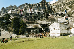
Spend the day at Manang in order to acclimatize yourself for crossing over the thorang la. It is possible to cross the ridge north of Annapurna IV, II, and Glacier Dome or to descend from village to the glacial lake at the foot of a huge icefall descending from the northern slopes of Gangapurna. Manang village itself is compact collection of slightly over 500 flat roofed houses whose entrances are reached from the narrow alleys that interweave among them by ascending a steep log notched with steps. overnight same lodge.
Day 10: Trek to YAK KHARKA (4018m) 4 hours walk.
This trail climbs to latder along the riverside, passing a village thicket and meadows where horse and yaks graze, at an elevation of 4250 m the second to last camp before the pass. overnight nice lodge.
Day 11: Trek to THRONG BASE CAMP (4450M.) 4 hours walk.
The trek now begins the 1800 meters ascent to Throng La. Begin by climbing up to the upper portion of Manang village, then climb out of Marsyangdi valley and turn northwest. The trail now goes north passing through scrub juniper and alpine grasses. After passing the last shelter, a two storey stone house, the trail ascends less steeply then crosses the Jarsang Khola on a small wooden bridge at 4300m.overnight nice lodge.
Day 12: Trek to MUKTINATH (3800M.) 8 hours walk.
The trail is comes steep immediately after leaving the camp, upmoraines and following rocky ridges as it ascends to the pass. As this trail was once followed by local people for hundred of years, the trail although steep is well defined and easy to follow. The only complication is the high elevation and the possibility of snow. The pass with its traditional chorten and stone cairn built by travelers is reached at 5416 metres about four hours from the last camp. The descent is steep - a loss of more than 1600 metres in less than three hours. The trail begins the descent in snow, which changes into moraines, and then finally yield to grassy slopes and the final descent to muktinath is a pleasant walk along the upper part of Jhong khola valley.
Muktinath is an important pilgrimage place for both Hindus and Buddhists a like sited in a grove of trees the holy shrines at muktinath include a Buddhist gompa and the pagoda style temple of Jwala Mai containing an image of bishnu. overnight nice lodge.
Day 13: Trek to Marpha (2670M.) 7 hours walk.
This day the way about 6 hours walk and we pass through and begins a steep descent to the floor of the valley. The trail is now the world's deepest gorge and follows this to Tukche. However, your trip is through the village of Kagbeni. the kagbeni is very old village and have very old monastery and the colourful pray flag on the roof of the houses and looks very different colours, very old house and such nice Landscape in this valley the way divided from here to Mustang also about half hour you have to spend here for looking round the village and visit to monastery the monastery entrance fee it cost 100 ruppees for tourist per person after your visit through the Jomsom it takes about 4 hours way to walk to Marpha, following the kaligandaki wide valley with the very nice view of Tilichok and Nilgiri North with the dry landscape but these day starting from Muktinath would be good in early morning about 7 o'clock. because in afternoon in this valley daily very strong wind blows pushing you backward. overnight nice lodge.
Day 14: Trek to KALOPANI (2540M.) 6 ½ hours walk.
About the trail description these day not up and down way must of flat, the way follows the kaligandaki river from on the way we will see very nice view on the right side of dhaulagiri ice fall, Dhaulagiri 1, Thapa peak , Tuckche peak, and left side Nilgiri north, Nilgiri west, Annapurna and Tilichok peak. Left side of infront nice hills with green forest valley and wide valley of the kaligandaki. and also we will pass for about 5 villages with coulourful temple, stupas on the way. overnight nice lodge.
Day 15: Trek to TATOPANI (1190M.) 7 hours walk.
This day is Long way to get Tatopani , early morning from Kalopani and Lete is very nice view again Dhaulagiri Glacier, Dhaulagiri 1, Nilgiri north, Nilgiri west, Annapurna 1, and the Trail also is many Zigzag and Rocky also most of down hill, passing many village on the way, and Kaligandaki deepest gorge you will be in this day. and the rupsi chahara is one of the best lunch place with the cool blowing water vapour you will have lunch here. this day is hot temperature because of getting in lower height. overnight nice lodge.
Day 16: Trek to Ghorepani (2750m.) 7 hours walk.
This day will have to start early morning also arround 7o' clock because we leave kaligandaki valley and climbing leftside to gorepani in the begginging of starting to climbing about 1 and half hour is steep uphill and after slide up to the Ghara the Mix village passing and we get sikha all mangar village there we will see again the mountains backside and valley of the Kaligandaki and also lunch here. Until here will be hot but after here will be cold. Ghorepani is One of the such great view point of Annapurna region trek, Left side we see many mountains of Machhapuchre, Annapurna1, Annapurna 3, whole Annapurna and Manaslu also and Right Side whole Dhaulagiri and Kaligandaki valley very nice place. overnigh nice lodge.
Day 17: Trek to Tadapani (2520m.) 5 hours walk.
This day early morning about 5 o'clock we have to go to Poonhill about onehour to Get to the Poonhill 3200m the best panoramic view for sunrise and mountain green valley view. You will enjoy to see these magnificiant view about half and hour and back to camp Ghorepani it will take half an hour and have breakfast and after breakfast starting walk to Tadapani also from camp side about 40 minutes is uphill and get to the Ridge about same view from the Poon hill and after deurali it get to the valley down in forest following stream (small River) and get Bunthanti is 20 minutes flat and 10 minutes down and 30 minutes up and you will get to the Tadapani this day is you walk in real colourful rhododhendron forest. This is best day for see the view and many different flowers. overnight in nice lodge.
Day 18: Trek to Nayapul 6 1/2 hours walk.
This day walking most down hill also until the Ghandruk with many different flowers on the ground and left side the round white mountains this is really colourful magnificiant view until the Ghandruk. Ghandruk is one of the best gurung culture place also there is very old Gurung culture museum. and from Ghandruk Right side down to get sauli bazar passing many steps to down hill and lunch here and after lunch to get nayapul about two hours following the Modi river valley the flat way and by Taxi drive to pokhara. about 1 hour drive. overnight in lake view resort.
Day 19: pokhara - to- kathmandu by tourist bus about 6 hours drive the lunch will be prepared packlunch. overnight Nirwana garden hotel. 1 triple in BB plan.
Day 20: After your breakfast drive with your tour guide with a private transportation to Bhaktapur and sightseeing there, Changunarayan temple which is very old and famous and drive to Patan sightseeing around there and back to your hotel in Kathmandu.
Day 21: With private transport transfer to airport for departure.

© 2008 Adventure Geo Treks. All Right Reserved.
Design by Nepal Media Network | Valid XHTML 1.0